Chatham Islands
| Native name: Rekohu, Wharekauri | |
|---|---|
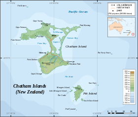 Topographical map of the Chatham Islands |
|
 |
|
| Geography | |
| Location | Southern Pacific Ocean |
| Archipelago | Chatham Islands |
| Total islands | 10 |
| Major islands | Chatham Island, Pitt Island |
| Area | 966 km2 (373 sq mi) |
| Highest elevation | 294 m (965 ft) |
| Highest point | Maungatere Hill |
| Country | |
|
New Zealand
|
|
| Largest city | Waitangi |
| Demographics | |
| Population | 650 (According to Chatham Islands Council) |
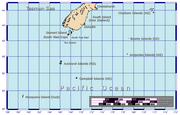
The archipelago of the Chatham Islands (Rekohu (misty sun) in Moriori; Wharekauri in Māori) is a New Zealand territory in the Pacific Ocean consisting of about ten islands within a 40 kilometres (25 mi) radius, the largest of which are Chatham Island and Pitt Island. These remote islands, over 800 kilometres (500 mi) east of southern New Zealand, have officially been part of New Zealand since 1842.
Contents |
Geography
- See also: Chatham Rise
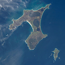
The islands are at about , roughly 800 kilometres (500 mi) east of Christchurch, New Zealand. They cover a total of 966 square kilometres (373 sq mi), almost all of which is in the two main islands.
The islands sit on the Chatham Rise, a large, relatively shallowly submerged (no more than 1000 metres deep at any point) part of the Zealandia continent that stretches east from near the South Island. The Chatham Islands are the only part of the Chatham Rise to emerge above the sea. The islands themselves have emerged only within the last four million years.[1]
The islands are generally hilly with the coasts a varied mixture including cliffs and sand dunes, beaches and lagoons. Pitt is more rugged than Chatham (Rekohu), although the highest point (299 metres (981 ft)) is on a plateau near the southernmost point of the main island, which is dotted with numerous lakes and lagoons, notably the large Te Whanga Lagoon as well as Huro and Rangitahi. Chatham has a number of streams including Te Awainanga and Tuku. The climate is cold, wet and windy with average temperatures between 5 and 10 degrees in July, the southern hemisphere winter.
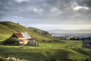
Chatham and Pitt are the only inhabited islands, with the remaining smaller islands being conservation reserves with access restricted or prohibited. The livelihoods of the inhabitants depend on agriculture, with the island being an exporter of coldwater crayfish in particular, and increasing tourism.
The names of the main islands, in the order of occupation are:
| Moriori name | English name | Māori name | Remark |
|---|---|---|---|
| Rekohu | Chatham Island | Wharekauri | |
| Rangiaotea | Pitt Island | Rangiauria | |
| Rangatira | South East Island | Rangatira | |
| Unknown | The Fort | Mangere | |
| Unknown | Little Mangere | Tapuenuku | |
| Motuhope | Star Keys | Motuhope | |
| Rangitatahi | The Sisters | Rangitatahi | about 16 kilometres (9.9 mi) north of Cape Pattison, a headland in the northwestern part of Chatham Island |
| Motuhara | The Forty-Fours | the easternmost point of New Zealand, about 50 kilometres (31 mi) from Chatham Island. |
The international date line lies to the east of the Chathams, even though the islands lie east of 180° longitude. Consequently, the Chathams observe their own time, 45 minutes ahead of New Zealand time, including during periods of daylight saving. (New Zealand Time orients itself to 180° longitude). Chatham Island is the antipodes of the French department of Hérault (Languedoc-Roussillon).
Subdivision
The Chatham Islands are subdivided into seven survey districts:
- Rangitihi Survey District (north)
- Rekohu Survey District (northeast)
- Tawirikoko Survey District (northwest)
- Te Whanga Survey District (center-north)
- Oropuke Survey District (south)
- Rangimene Survey District (southeast)
- Rangiuria Survey District (Pitt Island)
Ecology
The natural vegetation of the islands was a mixture of forest, scrubby heath and swamp, but today most of the land is fern or pasture covered, although there are some areas of dense forest and areas of peat bogs and other habitats. Of interest are the macrocarpa trees, with branches trailing almost horizontally in the lee of the wind. The ferns in the forest understory include Blechnum discolor.
The islands are home to a rich bio-diversity including about fifty endemic plants adapted to the cold and the wind, of which Chatham Islands forget-me-not (Myosotidium hortensia), Chatham Islands Sow-thistle (Embergeria grandifolia), rautini (Brachyglottis huntii), Chatham Islands kakaha (Astelia chathamica) , soft speargrass (Aciphylla dieffenbachii) and Chatham Island akeake or Chatham Island tree daisy (Olearia traversiorum) are among the best-known.
The islands are a breeding ground for huge flocks of seabirds and are home to number of endemic birds, some of them seabirds and some of them living on the islands themselves. The best known species are the Magenta Petrel and the Black Robin, both of which came perilously close to extinction before being subjected to conservation efforts. Other endemic species are the Chatham Island Oystercatcher, the Chatham Gerygone, the Parea or Chatham Islands Pigeon, Forbes' Parakeet, the Chatham Islands Snipe and the Shore Plover. A number of species have also gone extinct since European settlement, including the three endemic species of rail, Chatham Islands Raven and the Chatham Islands Fernbird.
There are also a number of endemic insects while mammals found in the waters of the Chathams include New Zealand Sea Lion, Leopard Seal, and Southern Elephant Seal.
Much of the natural forest of these islands has been cleared for farming, but Mangere and Rangatira Islands are now preserved as nature reserves to conserve some of this unique flora and fauna. Another threat to wildlife here comes from introduced species which prey on the indigenous birds and reptiles, whereas on Mangere and Rangatira livestock has been removed and native wildlife is recovering.
History
The first human habitation of the Chathams involved migrating Polynesian tribes who settled the islands about 1500 CE,[2], and in their isolation became the Moriori people. The exact origins of these people remain a matter of some dispute. The Moriori population of the islands numbered about 2000. Their agricultural resources were not suited for the colder Chathams, so they lived as hunter-gatherers, taking food from the sea and from native flora. Whilst their new environment deprived them of the resources with which to build ocean-going craft for long voyages, their intelligence and perseverance saw the invention of the most ingenious craft afloat. Moriori built what was known as the waka korari, a semi-submerged craft, constructed of flax and lined with air bladders from kelp. This craft was used to travel to the outer islands on 'birding' missions (King. M, 1989, Moriori, a people Rediscovered). The Moriori society was a peaceful society and bloodshed was outlawed by the chief Nunuku after generations of warfare. Arguments were solved by consensus or by individual duels rather than warfare, but at the first sign of bloodshed, the fight was over.
The name "Chatham Islands" comes from the ship HMS Chatham of the Vancouver Expedition, whose captain William R. Broughton landed on November 29, 1791, claimed possession for Great Britain and named the islands after the political head of the Royal Navy, John Pitt, 2nd Earl of Chatham. A relative of his, Thomas Pitt, was a member of the Vancouver Expedition. Sealers and whalers soon started hunting in the surrounding ocean with the islands as their base. It is estimated that 10 to 20 percent of the indigenous population soon died from diseases introduced by foreigners. The sealing and whaling industries ceased activities about 1861, while fishing remained as a major economic activity.
On November 19, 1835, a British ship carrying 500 Māori armed with guns, clubs and axes arrived, followed by another ship on December 5, 1835 with a further 400 Māori. They proceeded to massacre the Moriori and enslave the survivors. A Moriori survivor recalled: "[The Māori] commenced to kill us like sheep.... [We] were terrified, fled to the bush, concealed ourselves in holes underground, and in any place to escape our enemies. It was of no avail; we were discovered and killed - men, women and children indiscriminately". A Māori conqueror justified their actions as follows: "We took possession... in accordance with our customs and we caught all the people. Not one escaped....."[3]
After the invasion, Moriori were forbidden to marry Moriori, nor to have children with each other. All became slaves of the Ngati Tama and Ngati Mutunga invaders. Many died from despair. Many Moriori women had children to their Maori masters. A small number of Moriori women eventually married either Maori or European men. Some were taken from the Chathams and never returned. Today, in spite of the difficulties and genocide that Moriori faced, Moriori are enjoying a renaissance, both on Rekohu and in the mainland of New Zealand. Moriori culture is being revived and they have celebrated the opening of the new Kopinga Marae (meeting house) in January 2005.
An all-male group of German Lutheran missionaries arrived in 1843. After a group of women were sent out to join them three years later several marriages ensued, and many members of the present-day population can trace their ancestry back to the missionary families.
In 1865 the Maori leader Te Kooti was exiled on the Chatham Islands.
Origin claims
Moriori have received recognition from the Crown and Government and some of their claims against those institutions for the generations of neglect and oppression have been listened to and acted on. Moriori are recognised as the original people of Rekohu. The Crown also recognised the invading Maori tribe: Ngati Mutunga as having "indigenous" status in the Chathams by right of 160-odd years of occupation. Both groups have been given settlement packages of fishing quota.
It had been thought since the 1800s that the original Moriori arrived directly from more northerly Polynesian islands, which would make the Moriori's fishing rights claim invalid. However, current research indicates that ancestral Moriori were Māori who came to the Chathams from New Zealand about 1500.[4][5][6][7] As Kerry Howe puts it,
Scholarship over the past 40 years has radically revised the model offered a century earlier by Smith: the Moriori as a pre-Polynesian people have gone (the term Moriori is now a technical term referring to those ancestral Maori who settled the Chatham Islands).'[8]
Modern inhabitants, descendants of those who invaded and conquered the archipelago in 1835, claim access to ancestral Māori fishing rights. An extensive report on these claims, "Rekohu", has been published by the Waitangi Tribunal.[1]
Population
Chatham and Pitt Islands are inhabited, with 609 residents in the 2006 Census.[9]. The town of Waitangi is the main settlement with some 200 residents. There are other villages such as Owenga, Te One and Kaingaroa, where there are two primary schools. A third school is on Pitt Island. There are also the fishing villages of Owenga and Port Hutt. The population is mainly of European, Māori and Moriori background; 64% said they identified as Māori (which includes Moriori), and around 75% identified as European or New Zealander.[10]
Waitangi facilities include a hospital with resident doctor, bank, several stores, and engineering and marine services. The main shipping wharf is located here.
Transportation
Visitors to the Chathams usually arrive by air from Christchurch, Auckland or Wellington (around 1.5 – 2 hours from Christchurch on a Convair 580) to the airport on Chatham Island. While freight generally arrives by ship (4–5 days' sailing time), the sea journey takes too long for many passengers, and is not always available.
The Chathams are part of New Zealand so there are no border controls or formalities on arrival, but visitors are advised to have prearranged their accommodation on the islands. Transport operators may refuse to carry passengers without accommodation bookings. There is no scheduled public transport but accommodation providers are normally able to arrange transport.
For many years a Bristol Freighter served the islands, a slow and noisy freight aircraft converted for carrying passengers by installing a passenger container equipped with airline seats and a toilet in part of the cargo hold. The air service primarily served to ship out high-value export crayfish products.
The grass landing-field at Hapupu, at the northern end of the Island, proved a limiting factor, as few aircraft apart from the Bristol Freighter had both the range to fly to the islands and the ruggedness to land on the grass airstrip. Although other aircraft did use the landing field occasionally, they would often require repairs to fix damage resulting from the rough landing. Hapupu is also the site of the JM Barker (Hapupu) National Historic Reserve (one of only two in New Zealand) where there are momori rakau (Moriori tree carvings).
In 1981, after many years of requests by locals and the imminent demise of the aging Bristol Freighter aircraft, the construction of a sealed runway at Karewa, Tuuta Airport, allowed more modern aircraft to land safely. The Chathams' own airline, Air Chathams, now operates services to Auckland on Thursdays, Wellington on Mondays, Wednesdays and Fridays and Christchurch on Tuesdays. The timetable varies seasonally, but generally planes depart the Chathams around 10.30 am (Chathams Time) and arrive in the mainland around noon. There they refuel and reload, and depart again at around 1 pm back to the Chathams. Air Chathams operates twin turboprop Convair 580 aircraft in combi (freight and passenger) configurations and Fairchild Metroliners.
Black Robin Freighters operates shipping services from Timaru and Napier.
There is a small section of tar sealed road between Waitangi and Te One, but the majority of the island's roads are gravel.
Government
Electorates
Until the 1980s the Chathams were in the Lyttelton electorate, but since then they have formed part of the Rongotai general electorate, which mostly lies in Wellington. Annette King is the MP for Rongotai. The Te Tai Tonga Māori seat (held since 2008 by Rahui Katene) includes the Chatham Islands.
Local government
Local government on the islands, uniquely within New Zealand, involves a council established by its own Act of Parliament, the (Chatham Islands Council Act 1995)[11]. The Chatham Islands Council operates as a district council with regional council functions, making it in effect a unitary authority but with not quite as many responsibilities as the others. Some Regional Council functions are being administered by Environment Canterbury, the Canterbury Regional Council.
State services
Policing is carried out by a sole-charge constable appointed by the Wellington police district, who has often doubled as an official for many government departments, including court registrar (Department for Courts), customs officer (New Zealand Customs Service) and immigration officer (Department of Labour - New Zealand Immigration Service).
A District Court judge sent from either the North Island or the South Island presides over court sittings, but urgent sittings may take place at the Wellington District Court.
Because of the isolation and small population, some of the rules governing daily activities undergo a certain relaxation. For example, every transport service operated solely on Great Barrier Island, the Chatham Islands or Stewart Island/Rakiura need not comply with section 70C of the Transport Act 1962 (the requirements for drivers to maintain driving-hours logbooks). Drivers subject to section 70B must nevertheless keep record of their driving hours in some form. See New Zealand Gazette 14 August 2003.
Health
The partially-elected Hawke's Bay District Health Board provides the islands with health services.
Education
There are three schools on the Chathams, at Kaingaroa, Te One and Pitt Island. Pitt Island and Kaingaroa are staffed by sole charge principals while Te One has three teachers and a principal. These schools cater for children from Year 1 to 8. There is no secondary school on the Chathams. The majority of secondary school aged students leave the island for boarding schools in New Zealand. A small number remain on the island and carry out their secondary education through correspondence.
Economy
Electricity Generation
At present, the island is powered by a number of diesel generators. In July 2009, final plans were made for the installation of two 200 kW wind turbines to provide most of the power on the island.[2]
In fiction
In Jules Verne's Robur the Conqueror, Robur anchors his flying vessel Albatross over the Chathams after the horizontal propellers are damaged in a storm.
The novel Cloud Atlas includes the diary of a fictitious 19th century American traveller who passes through the Chathams.
In Joe Buff's futuristic nuclear submarine warfare book Crush Depth (ISBN 0-06-000964-0), Chatham Island is destroyed by an Axis planted atomic bomb.
See also
- History of Chatham Islands numismatics
- Flora of the Chatham Islands
- Chatham Islands Penguin
References
- ↑ McGlone, Matt (21 September 2007). "Ecoregions: The Chatham Islands". Te Ara – the Encyclopedia of New Zealand. http://www.teara.govt.nz/TheBush/UnderstandingTheNaturalWorld/Ecoregions/9/en. Retrieved 2009-02-08.
- ↑ B. McFadgen (March 1994). "Archaeology and Holocene sand dune stratigraphy on Chatham Island". Journal of the Royal Society of New Zealand 24 (1): 17–44.
- ↑ Diamond, Jared (1997). Guns, Germs, and Steel: The Fates of Human Societies. New York: W. W. Norton. p. 53..
- ↑ Ross Clark (1994). Moriori and Maori: The Linguistic Evidence. In Sutton, Douglas G. (Ed.) (1994), The Origins of the First New Zealanders. Auckland: Auckland University Press, pp. 123–-135.
- ↑ Denise Davis and Māui Solomon (2006). Moriori, Te Ara - the Encyclopedia of New Zealand, updated 9-Jun-2006.
- ↑ Kerry R. Howe (2006). Ideas of Māori origins, Te Ara - the Encyclopedia of New Zealand, updated 9-Jun-2006.
- ↑ Michael King (2000). Moriori: A People Rediscovered (Revised Edition). Published by Viking. ISBN 0-14-010391-0. Original edition 1989.
- ↑ Kerry R. Howe (2003). The Quest for Origins: Who First Discovered and Settled New Zealand and the Pacific Islands? Auckland:Penguin, page 182
- ↑ Quickstats about Chatham Islands Territory
- ↑ Ethnic groups, birthplace and languages spoken, QuickStats About Chatham Islands Territory, 2006 Census. Wellington: Statistics New Zealand. Retrieved 19 January 2010.
- ↑ Chatham Islands Council Act 1995 Statute No 041, Commenced: 1 November 1995, retrieved 4 February 2008.
External links
- Chatham Islands Council
- Hokotehi Moriori Trust
- 1998 Information
- Photographs from the Christchurch Public Library
- Education Resources from Kopi Holdings
- Department of Conservation information
- Unofficial Flag
- Chatham Islands Council Act 1995
- Massey University study of Chathams ecology
- Information and pictures of Chatham Islands. The Sisters are also mentioned
- Pitt Island
- Rekohu
|
|||||||
|
|||||||||||||||||||
| Supranational level | Realm of New Zealand | ||||||||||
|---|---|---|---|---|---|---|---|---|---|---|---|
| National level | New Zealand | Tokelau | Cook Islands | Niue | Ross Dependency | ||||||
| Regions | 11 non-unitary regions | 5 unitary regions | Chatham Islands | Kermadec Islands | sub-Antarctic islands | ||||||
| Territorial authorities | 13 cities and 53 districts | ||||||||||
| Notes | Some districts lie in more than one region | These combine the regional and the territorial authority levels in one | Special territorial authority | Areas outside regional authority; these, plus the Chatham Islands and the Solander Islands, form the New Zealand outlying islands | State administered by New Zealand | States in free association with New Zealand | Claimed by New Zealand | ||||